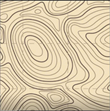
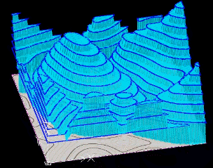
Topo
Tracer
creates
a 3D landscape relief in a drawing by tracing a 2D topographic image and generating a 3D
mesh, surface, or solid.
You
start by attaching a topographic image to a drawing and selecting an area to trace. You
can use
the
autotrace feature to trace the contour lines automatically, or trace
each line manually. You can split lines, and join the end points of two lines to create
a continuous line. The Height Scale option lets
you specify the relationship between the height of the contour lines in the 2D image and
the DraftSight units that are used in the
drawing.
When
you finish tracing all lines and assigned elevations, you can
generate a polygon mesh, face, or solid 3D landscape
relief.
| Original Topo Map |
 |
| 3D Relief Solid |
 |