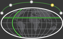
Sun and earth graphic 
|
Lets you
specify
the Sun Incline,
Latitude, and
Longitude graphically. Click one of the suns to
specify
the Sun Incline, or enter it
precisely by changing Time (time of
day is the biggest factor in determining the incline of the
sun at a fixed geo-location). The sun on the far right is
0º, then 45º, then 90º over the north pole, then 135º, then
180º.
Click the latitude and longitude
lines to
specify
their approximate values.
|
| Calendar |
Specifies
the month, date, and year to simulate. |
| Current
Date and Time |
Specifies
the time of day simulated on a 24-hour clock. In combination
with
Calendar,
Latitude, and
Longitude,
Time determines the Sun
Incline. |
| Set Time to Now |
Uses your system time for Month and Time. |
| Latitude |
Specifies
the latitude of the location to simulate. |
| Longitude |
Specifies
the longitude of the location to simulate. |
| Sun Incline |
(Read-only.)
Displays the altitude of the simulated sun in the environment
sphere. |